
VECTOR = Validation & Enhanced Calculation of Tactical Operational Routing
AireonVECTOR leverages Aireon’s global, real-time, space-based automatic dependent surveillance-broadcast (ADS-B) data and the precision of its advanced Iridium satellite backbone, to pinpoint the location of the aircraft independent of the onboard GPS. Using our proprietary algorithm, VECTOR provides a validated, independent source of aircraft position data for enhanced operational and safety awareness.
What is AireonVECTOR Flight?
AireonVECTOR Flight generates an independent “truth position” for any ADS-B equipped aircraft without relying on the aircraft’s position solution (onboard GPS).
- Space-Based TDOA
- Use Time Difference of Arrival measurements from Aireon’s 66-satellite LEO constellation to calculate aircraft true location.
- Avionics-Independent
- Produces a positional data layer not dependent on aircraft avionics; the aircraft doesn’t know it’s being tracked this way.
- Truly Global
- Operates globally including oceanic, polar, and remote regions where no ground-based alternative exists.
- Real-Time Indicators
- Detect divergence between ADS-B positions and VECTOR positions, identifying position anomalies and spoofing events as they occur.
“We calculate where the aircraft actually is, independent of what the aircraft is telling us.”
Why it matters?
- Signal Validation
- Flags accurate ADS-B messages and cross-checks reported positions.
- Position Anomalies
- GPS spoofing, avionics manipulation & Cyber Events.
- Fills Gaps in Information
- Incomplete transmissions.
Unique Space-Based Positions: Time Difference of Arrival
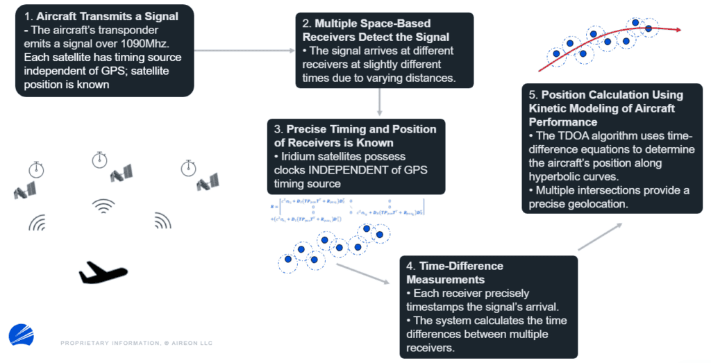
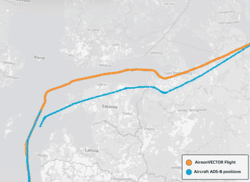
The Aireon algorithm uses a ground-breaking analytical technique to calculate a “reference position” based on Time Difference of Arrival (TDOA) and independent kinematic modeling. Under normal conditions, this reference position aligns with the ADS-B transmitted position. However, in cases of single interference and spoofing, Aireon can detect real-time divergence between the reference and reported positions, providing an immediate indicator of degraded GPS integrity.
Aircraft Position Spoofing & Gap Fill
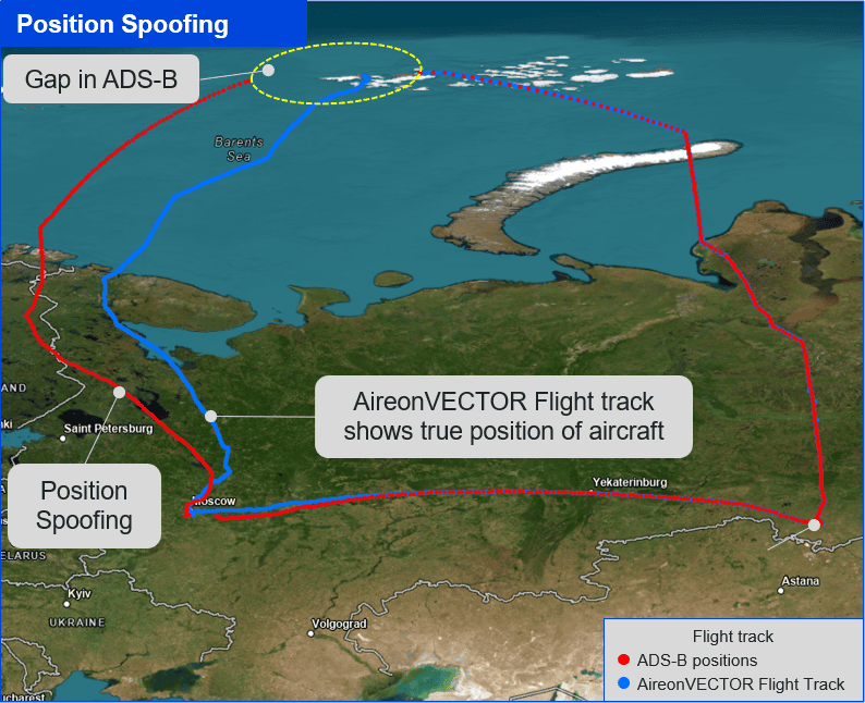
In this graphic, Aireon data shows a Mode S transponder associated with a cargo aircraft flew in June 2025 with a number of its ADS-B broadcasted positions in locations over eastern Finland, while the VECTOR Flight positions were calculated further to the East.
AireonVECTOR Flight data is a calculated estimate of the aircraft’s true position using a space-based time difference of arrival algorithm.
Aireon satellite TDOA tracking provides additional flight awareness in regions where GPS is spoofed or jammed and/or where incomplete ADS-B messages are received.
Interested in learning more or scheduling a demo? Contact us at info@aireon.com.
