With nearly a third of Aireon’s space-based Automatic Dependent Surveillance-Broadcast (ADS-B) payloads already active in orbit, and with several successful flight tests under its belt, Aireon is well on its way to bringing the first truly global aircraft tracking and surveillance system to fruition. Recently, Aireon’s Director of System Engineering, Dr. Mike Garcia took some time to answer a few questions about how the AireonSM system works, and how well it is functioning (Spoiler Alert: In many ways, even better than expected!):
Q: The Aireon payload is designed to pick up ADS-B broadcasts from properly equipped aircraft anywhere in the world. Can you provide a bit more insight into how the payloads operate, and give an overview about payload footprints?
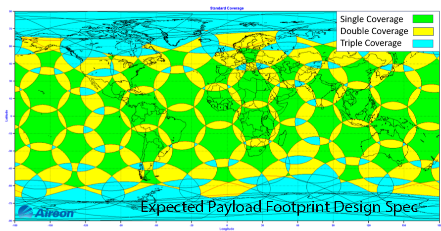
A: The payloads operate by receiving ADS-B messages from aircraft over the 1090 MHz frequency. ADS-B messages relay information like aircraft identification, altitude, position and velocity to air traffic controllers or an aircraft operators control center. Each payload supports multiple “beams” that are focused on the earth’s surface, creating a large and robust payload footprint. The way we determine each payload footprint, is by looking at the aggregate coverage from multiple beams, from the same satellite, with a slant range of approximately 3000 km. This larger slant range creates larger footprints of overlapping coverage per payload, ultimately resulting in a more robust surveillance system.
Once data is received, each payload uses the Iridium® NEXT global, low-Earth-orbit satellite network to transport the collected data down to the ground, in real-time, to then be delivered to Air Navigation Service Providers (ANSPs) or aircraft operators around the world.
Q: Aireon has already received billions of ADS-B position reports with just nearly a third of the constellation payloads deployed and currently active (as of this blog). How have the initial payloads been performing?
A: Excellent! We evaluate conformance for each payload, which compares our model of how the payload should perform to its measured actual performance. So far, all payloads are well exceeding their initial expectations, but there is still a lot more testing yet to be done over the next several months.
Q: How do overlapping payload footprints help increase effectiveness versus just showing signal redundancy?
A: Each payload has an independent chance to receive a message transmitted by an aircraft. The more payloads with footprints that overlap on an aircraft’s position, the greater the likelihood each message will be received.


The footprint of each payload is like a spotlight shining on Earth. How wide of a circle of light, depends on each satellite’s slant range, or the angle it is directed at the earth’s surface. Each payload in the Aireon system was expected to have a slant range of 2500 km and provide double redundancies in most areas with minimal coverage gaps. The actual slant range of each payload is closer to 3000 km and provides triple redundancy even in much of the equatorial region where satellites are farthest apart. This is a static image, but in reality, each satellite orbits the earth every 100 minutes, and the coverage moves throughout the globe.
Q: What were the expected payload capabilities versus the actual performance you’ve seen so far?
A: The initial slant range of the payload was assumed to be around 2500 km; the actual range has been measured above 3500 km on many occasions. This extended range brings benefits to our overall system performance, improving update intervals, availability, and redundancy.
Q: Any other unique insights or important points regarding payload performance or unique attributes you’d like to share?
A: The payload is an amazing device, and the engineers at Harris Corporation down in Melbourne, FL truly set a new standard for ADS-B receiver systems. So far, we have already received over 10 billion ADS-B position reports without a fully operational system. Imagine the numbers with all 66 satellites!
Dr. Garcia also published a paper in April 2017 on the early analysis on payload footprints that may provide more insight.