
AireonVECTOR
Family of products for identifying and mitigating the impact of GPS interference in aviation
AireonVECTOR (Validation & Enhanced Calculation of Tactical Operational Routing) leverages Aireon’s global, real-time, space-based automatic dependent surveillance-broadcast (ADS-B) data to pinpoint the location of aircraft independent of the GPS signal via a proprietary algorithm. This suite of tools and resources is designed to help aviation stakeholders stay apprised in real-time of changes in the GPS signal reliability.
Our products combine the highest quality data with valuable insights

Real-time insight into signal disruption and its impact
Leveraging a COTS visualization tool, AireonVECTOR Monitor provides detailed, real-time airspace data for ANSPs, allowing the users to perform detailed analytics into the sources and impacts of signal interference.

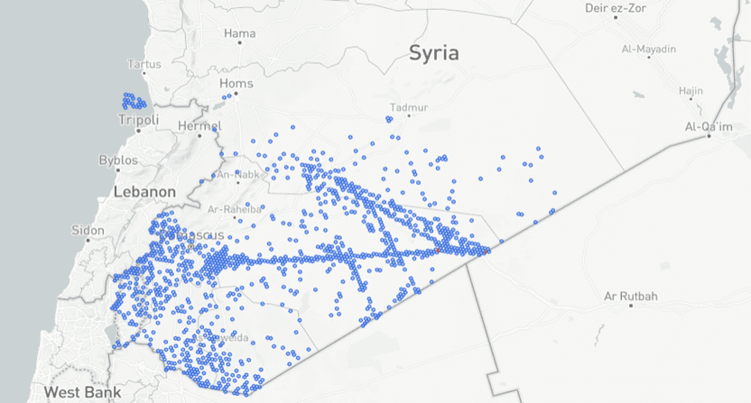
GNSS interference mapped hourly
Turn an aircraft into a distributed sensing network, detecting GNSS interference, spoofing, and jamming with precision — hourly and globally. Built on Aireon’s unmatched space-based ADS-B infrastructure, VECTOR Map delivers standardized geospatial intelligence to support smarter route planning, pattern-of-life analysis, and situational awareness — even in remote and oceanic regions.

Fill in the gaps and uncover interference in flight tracks
Using AireonVECTOR Flight, this product provides information to reduce long-gaps in a flight track to provide a complete flight profile, highlighting the areas of interference. This product combines ADS-B messages received directly via Aireon’s satellite network with AireonVECTOR’s calculated aircraft positions, to provide a full flight path even in areas of GPS Interference.

Real-time insight into signal disruption and its impact
Leveraging a COTS visualization tool, AireonVECTOR Monitor provides detailed, real-time airspace data for ANSPs, allowing the users to perform detailed analytics into the sources and impacts of signal interference.
See the power of AireonVECTOR™
AireonVECTOR provides real-time visibility into GPS signal integrity by detecting and analyzing interference such as jamming and spoofing. Leveraging Aireon’s global, space-based ADS-B data, AireonVECTOR delivers GPS-independent aircraft positioning, interference trend monitoring, and visualization tools to help aviation stakeholders enhance operational awareness and ensure navigation resilience.
Spotting GPS/GNSS Interference: Jamming and Spoofing Explained
Understand the threats of GPS/GNSS jamming and spoofing, how they differ, and their implications for safe aircraft navigation.
Spoofing Defined:
A cyberattack where false GPS/GNSS signals are transmitted to a receiver.
Unlike jamming, which entirely blocks or disrupts GPS/GNSS signals, spoofing alters the signals to deceive a receiver into accepting incorrect data. This manipulation can lead to the display of false information regarding aircraft position, speed, or time, potentially causing dangerous outcomes in applications that rely on accurate GPS/GNSS data.
Signs of Spoofing:
- Inconsistent or incorrect aircraft location data
- Unexpected changes in navigation
- Sudden jumps in aircraft position
- GPS/GNSS signal strength seems normal
- Mismatch between visual landmarks and GPS/GNSS data
- Multiple GPS/GNSS devices report different locations
- Odd time shifts
- Loss of GPS/GNSS accuracy
- No clear obstructions
Jamming Defined:
Intentional or unintentional disruption of the signals transmitted by GPS/GNSS satellites.
This interference prevents GPS/GNSS receivers from accurately determining aircraft position, velocity, and time. Jamming typically occurs when a device emits radio frequency signals that overpower or drown out the legitimate GPS/GNSS signals, leading to degraded or completely blocked functionality.
Signs of Jamming:
- Loss of GPS/GNSS signal
- Aircraft position drift
- Error messages
- Time inaccuracy
- Intermittent service
- Unusual navigation routes (including impossible or illogical paths)
- Multiple devices affected in the same time and area
- Longer time to lock aircraft position
Have questions about AireonINSIGHTS?
Connect with Aireon to learn how INSIGHTS can support your business operations.
Have questions about AireonVECTOR?
Connect with Aireon to learn how VECTOR can improve your GPS signal reliability.
"*" indicates required fields

Our products combine the highest quality data with valuable insights


Event-based flight information
AireonINSIGHTS family of products — including Aireon Locate — put the power of our dataset into your hands. Whether you are a first responder needing to locate an aircraft with Aireon Locate or an operator wanting to ensure the integrity of the GPS signal in your airspace, AireonINSIGHTS is there for you.

Real-time GPS interference detection
AireonVECTOR is a suite of products that uses Aireon’s space-based ADS-B data to detect and visualize GPS interference—such as jamming and spoofing—in real time. By generating a GPS-independent “truth position” of aircraft, AireonVECTOR empowers aviation stakeholders with the insight needed to monitor, mitigate, and respond to navigation threats.